RER Train Line Maps
The following RER Train Line maps are specific to a single RER Train line, A, B, C, D, or E.
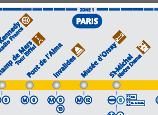
Each RER Line map shows:
- Stations along the RER line
- Branches & Terminus (last) stations for each branch, used to specify direction of travel for RER trains along their platforms within stations
- Interchanges or Connections to Paris Metro lines
- Connections to other RER train lines
- Transfers to TGV Trains, Transilien/Ter commuter train lines at large Paris train stations (known as “Gare” in French). This includes Gare du Nord , Gare de l’Est, Gare de Lyon , Gare de Austerlitz, Gare de Montparnasse, Gare St. Lazare.
- Zones for Pass Navigo / Paris Visite / Mobilis tickets and passes
- Handicap accessibility at stations
- Famous attractions near stations
These maps can be found on all RER train cars just above their doors.
What Next?
- Search
:
- Ask a question

Hi my name is Ben and I’m the creator & author of Parisbytrain.com . I want to empower you with the knowledge & confidence to travel Paris like a local through personally researched, in-depth articles like CDG to Paris by train and the Paris Metro . I moved to Paris in 2006 and started Parisbytrain.com in 2008 to share what I’ve learned about the vast & comprehensive Paris train network. Have Paris train questions? Ask them here . Have a great visit to Paris!

I want to support Ben
RER Train Line Maps
was last modified: October 28th, 2019
by
Pingback: How to Read an RER Train Schedule / Timetable | Paris by Train